
Wednesday 29th September saw South Pennine Archaeology Group holding its first post lockdown talk at Ashday Lea, Rawtenstall and what a talk it was! In Lancashire Maps before OS, Bill Shannon started by taking us back to Catal Huyuk in Turkey to a possible 8000 year old cave painting of the town!
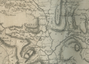
Yates Map of 1786
Moving quickly through the centuries we arrived at Saxton’s maps drawn in the 16th century, after which there was little development until Yates map of Lancashire, compiled in 1786. Early maps were less about denoting routes and more about identifying places, buildings and natural features like hills and rivers.
Using Yates’ map, Bill now focused on the Rossendale area, the largest town at the time being Haslingden. Cribden, Musbury Tor and Cowpe Lowe are clearly marked as is a quarry on the North side of Grane Road. Rawtenstall and Crawshawbooth appear to have three Meeting Houses but only the one at Crawshawbooth has the word Quakers before it.
We then moved onto Dispute Maps which provide an insight into land division in the late 1500s in particular. These were maps drawn specifically to determine land ownership and would be used in the courts in London.
To quote Bill ‘One such map of 1575 covers an extensive area of some 24 square kilometres, and is extremely fine, with many decorative features, including human and animal figures, and drawings of salmon and eel in the river Irwell and other brooks. Haslingden church, a water mill and numerous houses are shown, as well as hedges and trees. A highway, painted yellow, runs right across the map to Haslingden church, while Gregoryes Lane painted green, leads off it at right angles.
However, the most striking features of the map is the green wash used to indicate the Holden properties, the mapmaker apparently using solid green to depict pasture, while arable land is shown by green stripes. The Holden lands occupied the valley of the Ogden Brook, a tributary of the Irwell, on either side of which the steep valley slopes and moorland of Musberi Parke to the south and Haslingden Moor to the north are left uncoloured, as are the lands of neighbouring landowners.’
The evening concluded with a brief discussion on how to access the early OS maps by using https://maps.nls.uk/. A truly excellent talk enjoyed by 40 people. For more details of SPAG please visit https://digspag.org.uk/ .

