
Despite a weather forecast of a dry day, rain appeared on our windscreens on the journey to Clowbridge but from then on the forecast was spot on! After an intial briefing, to recognise the work that Dr David Taylor and the Pendle Heritage Group (PHG) undertook in the 1980s when they researched and excavated the site, we first visited the open air bapistry.
The baptistry was excavated by PHG and recently restored by United Utilities. With no water in it, our call for volunteers to be totally submerged in water straight off the fells was wasted but many people have done so in the past. Brrrrrrh!
 Walking to the site of the village for which the earliest record is as a vaccary (cattle farm) in 1242, by the 16th century it had cattle, horses and some sheep. In 1839, the strong non-conformist community used John Haworth’s house as a Baptist Chapel, with a ladder, sacks and boards as pews! The first pastor was the Rev James Maden who is buried at Goodshaw Chapel. The congregation grew to around 300 and briefly moved to the Brew House at the nearby Mansion House. In 1849 a new chapel was built but closed in 1866 when the reservoir was constructed.
There were seven coal mines in the area with two main shafts. Pumping Pit, just below the settlement used the enlarged baptistry for water for its engine. A tramway (partly underground) moved the coal to Swinshaw Hill where it was joined by coal from the mine there, thence to the coal staithe in Crawshawbooth. When Sunnyside Printing Works closed, (their main customer) so did the mines.
Clowbridge reservoir was built on the village cornfield and three of the roads to the outside world were also lost. People moved out to work in the mills and the thriving community disappeared, the last inhabiatants leaving in the 1890s. In the 1940s and 50s the village was demolished.
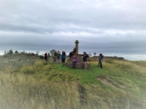 Walking East along the Southern boundary, we reached Compston’s Cross near the junction of four packhorse trails, the most important of which was Limersgate. This route was used for transporting lime from Clitheroe to Rochdale and locally produced woollen cloth to market. The cross was erected by Samuel Compston, a local historian and Mayor of Rawtenstall. Two other crosses were located just to the North and another, Higher or Red Moss Cross was on a route to Whalley Abbey, now close to the Rossendale Way. All that’s left is a stump.
Heading down Limersgate towards the A682 we turned left to view what is left of the Mansion House. Now just a few dressed stones remain of what was the home of the Ormerod family until 1874. Finally we returned to our cars to head off for a well earned lunch.
C

